
Date: 19th February 2021
time: 10:00 - 16:00
Duration: 6 Hours (incl. breaks)
Via: Zoom
Price: 100€
Nr. of students: 10 only (for the purpose of maximum student-instructor engagement)
To who: Military or Law enforcement active members, as well as firefighters and EMS.
*Recommended to Patrol officer / Infantry roles as well!
*Instructor: Active SF instructor, member of PG training team.
BACKGROUND INFO.
Maps, cross-team communication and situational awareness are critical to coordinated tasks in many contexts, including kinetic military action, law enforcement standard operations, civil protection, disaster relief, and many others. Geospatial data has been the purview of specialists for some time, and uniting up-to-date geospatial data with real-time situational awareness has been difficult.
Not any more.
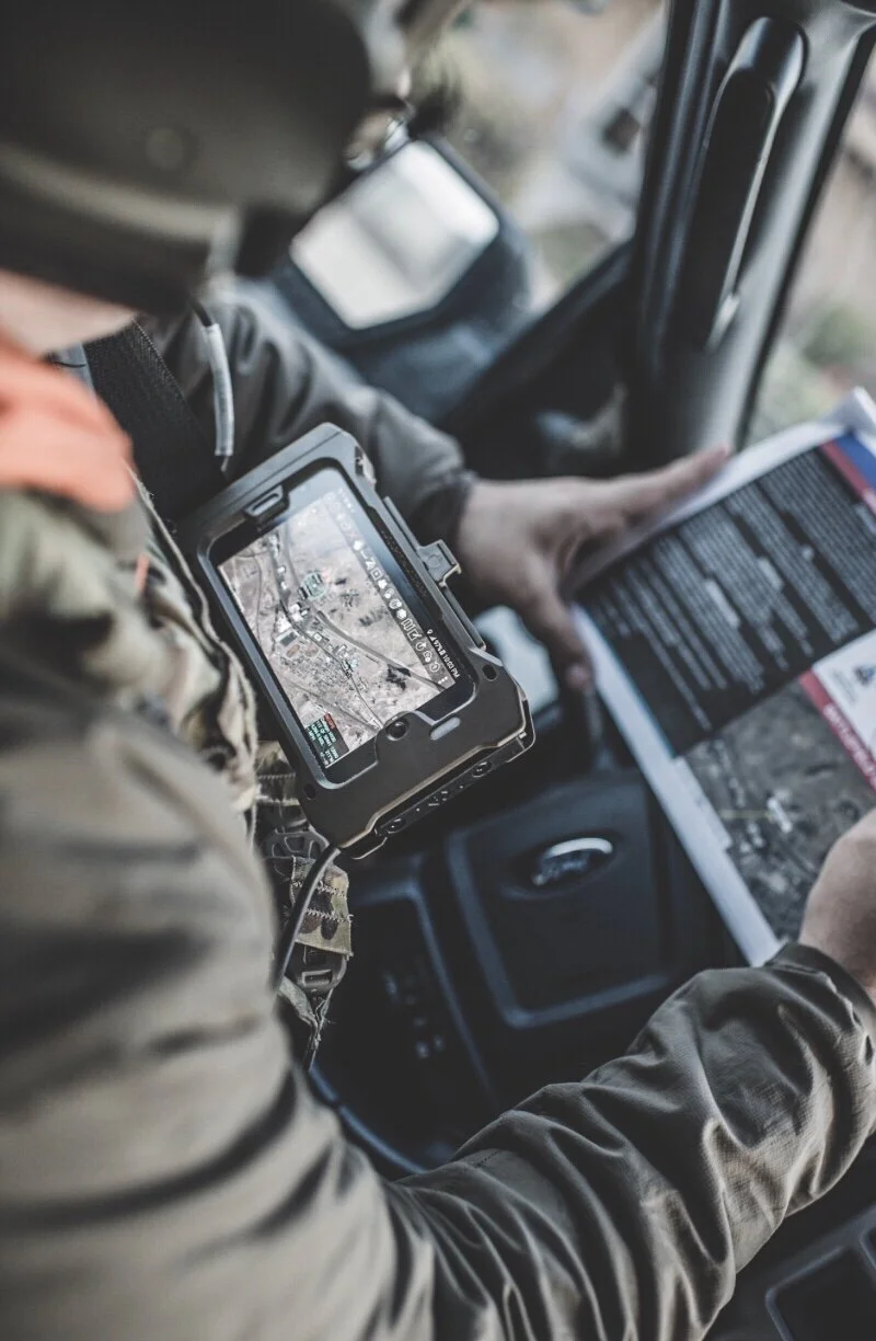
Meet ATAK.
Android Team Awareness Kit - or ATAK -is an affordable spatial Situational awareness program known for its user-friendly, encrypted, mobile, interactive geospatial capabilities that connect teams or people on the go, giving them a common operational picture digitally, in a unique real-time way. End This software, enables its end users to fully customize these tools to fit their own functionality and employ multiple types of communication systems simultaneously. It is the only app that provides dozens of capabilities and robust information-sharing in a mobile format on a commercial off-the-shelf handheld cell phone.
In other words, ATAK is an extensible platform, which gives you a baseline and based on your mission requirements you can build on that baseline to bridge capability gaps. This APP is extremely useful to type of jobs that require to display point location information – the military, law enforcement agencies, state and local authorities, firefighters and emergency responders – will benefit from the capabilities embedded into the ATAK app.
For what?
Situational awareness (SA) is important to the execution of tasks & missions at all levels, from admin to strategic to tactical. ATAK focuses on improving the SA of small units at the tactical & admin edge. This means, that individuals and organizations using this APP knowing at all times where they are, where the rest of your team is, and having a variety of ways to communicate with their team or across various teams (and, if feasible with reach-back, to operation centers). The software has successfully aided in search-and-rescue and natural disaster responses, such as coordinating the relief efforts following Hurricane Florence, recovering firefighters during the massive fires in California, or alternatively, supporting Law enforcement Command and control capabilities all the way to the local, patrol or SWAT level.
Due to its excellent mission planning, and SA features, ATAK is becoming a prime for several Special operations units around the globe.
OVERVIEW OF THE COURSE TOPICS.
SETUP AND OPTIMIZATION - Students will learn how to install, setup, and set up encryption for efficient, secure, and user-friendly use. Also, we will guide our students on how to set it up in a way the is useful TO THEIR work requirement. Users will learn how to
PERIPHERAL EQUIPMENT CONSIDERATIONS - How to carry on your equipment, Connectivity options in remote areas/cross-team, power considerations, and cables options and most importantly, what else you should run in addition to the APP in order to get the maximum out of it - what where and how.
MAP TOOLS - displays base georeferenced imagery and overlays other SA information (e.g., georeferenced points, annotations, etc.). Students will learn how to use the Overlay Manager which allows the Import and display of KML, KMZ, GPX overlays and maps, including online sources, and how to obtain map sources relevant to their home country. additionally, we will cover Location marking, sharing, history navigation-walking/hiking, driving-related Infos.
ANNOTATION TOOLS - Students will learn how to use tools that allow contributing SA information in real-time to other elements.
ROUTES CREATION AND DRAWING TOOLS - Students will learn how to produce routes, and to designate relevant criteria about the route.
MISSION PLANNING / MEASUREMENTS TOOLS - From terrain analysis to planning, students will learn how to employ proactively the app features to generate high level of SA, and terrain familiarity.
Additional topics covered:
Location marking, sharing, history
How to Chat, file sharing, photo sharing, video sharing, streaming for a variety of tactical tasks.
Elevation Tools, heat maps, computed contour maps, viewsheds, routes w/DTED, SRTM, including dynamic profiling
Hashtags and Sticky tags - for what, and how.
Center on Self, Center on other objects (e.g. another person in the network)
Range, bearing, and other measurement tools
Network-aware geofences with triggers
“Bloodhound” destination tracking, including on moving objects
Team Emergency Beacons
Customizable Toolbar
Radio controls and Integration
Photo to map capability (aka Rubber Sheeting)
Casualty evacuation tool
Icon support for a wide variety of First Responder missions with further extensible Icons
This course's main objective is to bring the individual to a level of which he can autonomously engage and use this APP for his routine work. Additionally, this course is aimed to give students all information needed in order to decide whether this app will benefit them or not.
BEFORE YOU BOOK:
You will need an android device (Tablet or phone)
Please reffer to this link, and download the APP on the device you wish to use, in order to check for compatibility issues.
For the course, you will be required to attend with a Web cam and a microphone
During the course, there will be several breaks
No screenshots or video capturing is allowed
The class is designed to be highly interactive. therefore you should feel free to raise questions, and engage in a 1on1 conversation with the instructor.